This is a guest post by Amit Chaudhary, an assistant developer at Code For Nepal.
I have been working with Code For Nepal for more than a year! Code For Nepal’s mission is to digitally empower Nepal. In an effort to do so, we recently launched NepalMap, a web app that makes data easily accessible and understandable. This is what Ravi Kumar, our co-founder wrote about NepalMap, in his recent Huffington Post article:

“Nepal has been conducting censuses for at least a century, starting in 1911. But it’s only been with the rise of the Internet that data has been, in theory, more widely available. However, most of the Nepal census data online today is still locked in PDF format, making it inconvenient for users to analyze and share. We wanted to change that.”
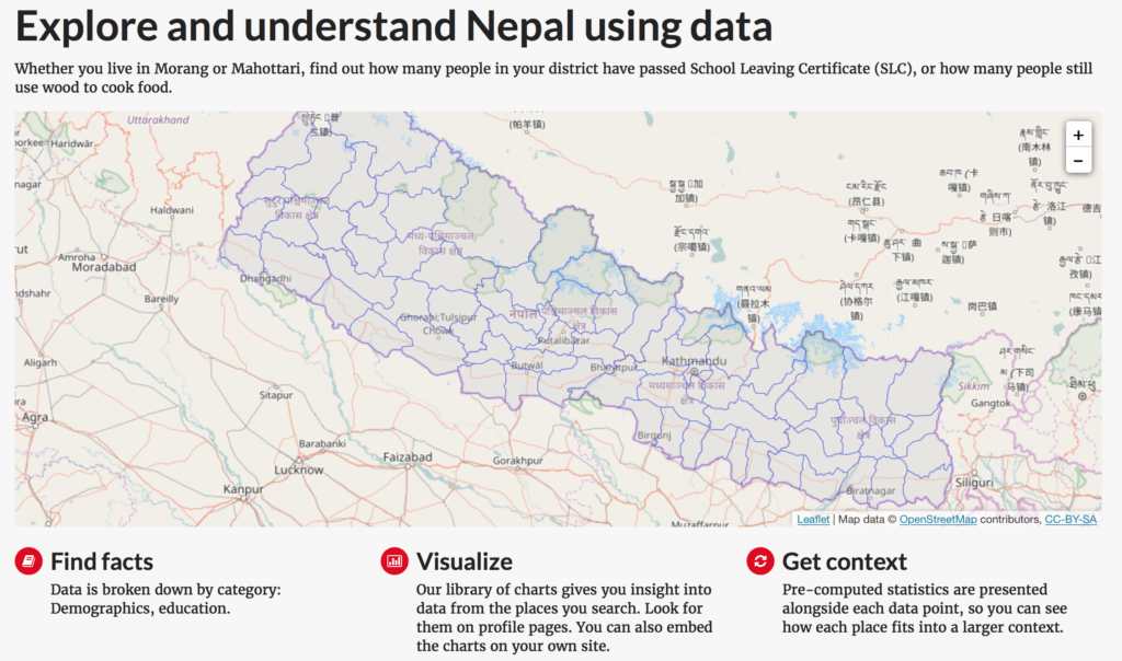
This month, Code for Nepal is excited to launch the beta version of www.nepalmap.org, a web app that puts data about Nepal at your fingertips!


NepalMap helps the user to find and understand data on Nepal easily and will be useful to anyone who seeks to learn more about Nepal via data.
Whether you live in Morang or Mahottari, you can use NepalMap to find out how many people in your district have passed School Leaving Certificate (SLC), or how many people still use wood to cook food.
You can compare two districts and find out which one has a higher life expectancy or even which one has more public toilets.


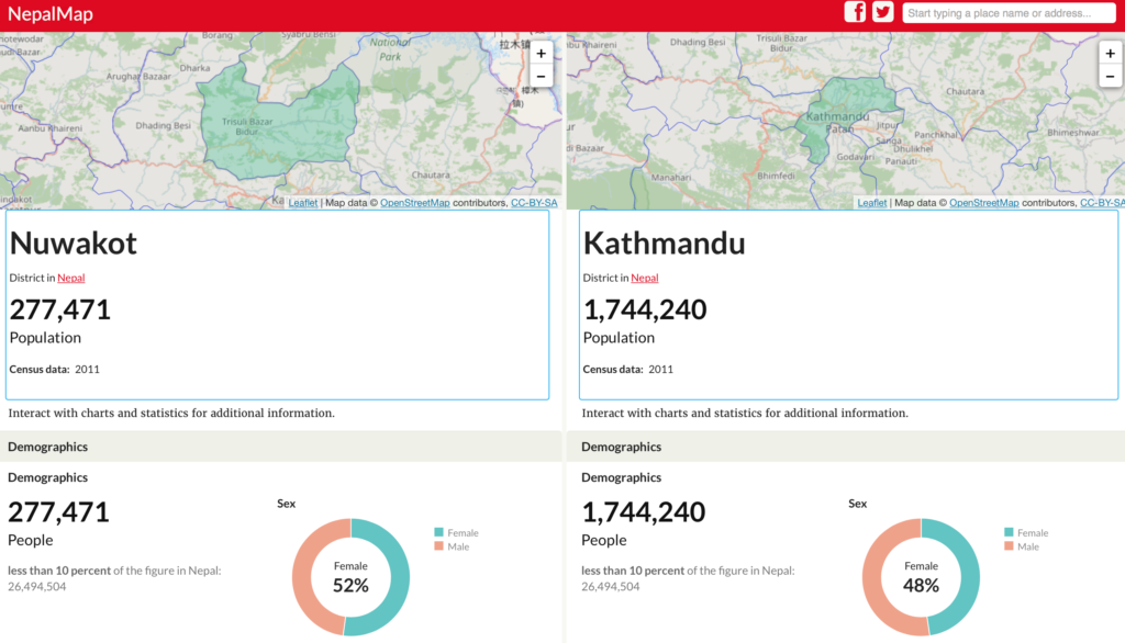
Journalists, researchers, and students will find NepalMap to be one of their best friends as they are looking for data. Entrepreneurs and businesses can better understand an area in which they are looking to do business by using NepalMap. Anyone can embed charts from NepalMap on their websites or download the data for their own use.
How it all began
Central Bureau of Statistics provides latest census data trapped in a lengthy PDF report. A standard format data such as CSV is more suitable for data processing. So, we converted the census data to a standard format. It has been released publicly here.
We wanted to build a tool around this data to put it into a simple and easy-to-use interface that includes data visualizations. We knew that a tool like this was already in development but for a different country — Kenya. The tool called Wazimap was itself based on Census Reporter, which was created in the USA; a great example of open source culture
So, a few of us collaborated to use WaziMap as the base for the project. Clifton McIntosh served as the lead developer for the project and NepalMap got started.
NepalMap is built completely using open source software which meant that Code for Nepal could use the platform’s underlying code at no cost, and build on top of it, in order to adapt the tool for Nepal’s datasets. It has helped us focus more on the data we want to open up rather than worrying about the technical details.
Tech Stack
The back end is written in Django and uses PostgreSQL for the database. It’s deployed on Microsoft Azure.
Workflow
All of us at Code For Nepal are volunteers and work remotely on our free time. Slack and email are our main tools for team communication.
We use GitHub for hosting the source code for NepalMap.
Feature requests and bugs for the project are managed using GitHub issues. Priority, labels, and estimate are set for each issue and the highest priority issues are tackled first. Development is done on the forks and pull request is sent to the original repo.
Each pull request goes through a peer review before merging. All development work is done on dev branch and then goes into test branch before finally merging into the master branch. Releases are done every 2/3 weeks depending on the number of features/bug fixes going out on that release.
How you can contribute
We are looking for volunteers for the project. If you’ve programming skills and want to contribute, you can start with the open issues here. If you have marketing skills and want to help us promote this, please complete this form!
You can also share NepalMap on social media to help us reach more people. We are always open to suggestions and feedback on your experiences when using NepalMap.
What’s on the roadmap
Currently, you can explore the data by district. We plan to integrate VDC level data into the app soon.
-
Skywell ET5 Launched: First Luxury EV with 620KM NEDC Range in Nepal!HIGHLIGHTS Skywell ET5 price in Nepal is Rs. 1.09 Crore. It gets a 150kW Motor…
-
Nothing Mobile Price in Nepal (April 2024 Updated)Nothing, stylized as ‘NOTHING‘, is a British smartphone manufacturer founded by OnePlus’ co-founder Carl Pei…
-
Apple iPhone Price in Nepal (April 2024 Updated)Apple doesn’t have many varieties when it comes to iPhones. iPhones get their new version…